Terris 3.1.7
Continue to app
Free Version
Publisher Description
• Let your registered contacts rapidly know your status and potentially your location in the event of an earthquake hitting.
• Check on the status of your registered contacts in the event of an earthquake hitting.
• Store up to 500,000 earthquakes offline. Search these saved earthquakes with ease and see their location on a global map and detailed information relating to them.
• Download historical earthquakes that have been missed.
• Use a stepper time control on the map to see how the selected quake relates to others in the quake time line.
Driving back to Wellington one Sunday evening after a weekend away, we were listening to the radio, when the program was interrupted with a news flash that Wellington* had been hit by a 6.4 magnitude earthquake.
The first thing we thought of was: Do we really want to go back to Wellington that night?
The second thing we thought of was: Start texting friends to ensure that they were OK. After a few texts, boredom and thumb strain set in, and it struck me that it would sort of useful to have an app that would automatically text one's contacts in the event of a suitably large earthquake. A 'Please help (me)' type of message including the latitude and longitude could be used, to ensure that ones friends actually called back to see if one was ok, and if one wasn't, at least they would have a latitude and longitude to start looking for one.
That seemed a bit over the top for the 99.9% of the time that one wouldn't be incapacitated by a collapsing building, so the ability to send an 'I'm Ok' or an '(Are) You Ok', as opposed to a help request, message would also be useful to send one's contacts.
Hence Terris.
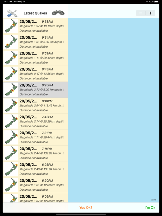
Terris originated as a New Zealand earthquake orientated app. Its intent is to regularly poll for earthquakes from different feeds, and present the user with a list of results. Current feeds are:
• GNS.
• USGS.
• EMSC.
• BGS.
• JMA.
The user can navigate into these results to see the location of the earthquake on a map view. They can further navigate to get finer details on each earthquake, and ultimately can view the quake in the originators site if required. A time control on the map allows the user to see how the current earthquake relates to previous and future earthquakes in the time line.
The earthquakes can be searched by feed (GNS, USGS, EMSC, BGS and JMA), magnitude, depth, date and distance to quake from the user's current location to limit the results displayed.
The user can set up the application, so that in the event an earthquake above a certain magnitude occurs, the application will attempt to rapidly prompt the user through the iOS SMS and Email systems to send either a 'Please Help (me)' request , or an 'I'm ok' confirmation notification messages to the user's registered contacts. The user has the option of sending their location in the help request, to aid with their rescue.
The user can register notification contacts via their address book or by free form text.
In the event that the user feels the earthquake before being prompted by the application, the user can choose to trigger the sending of the the 'Please Help' (me), 'You Ok?' or 'I'm Ok' notifications themselves.
We acknowledge the New Zealand GeoNet project (and its sponsors EQC, GNS Science and LINZ), USGS, EMSC, BGS and JMA for the use of their data.
Note that the notion of sending a help request with location coordinates does not have to be confined to an earthquake scenario. Twisting an ankle while out on a hike would be an example. You do want your friends to come and give you a hand, but you don't necessarily want all branches of the emergency services involved in a full blown search & rescue effort.
This application can use location services. Note that continued use of GPS running in the background can dramatically decrease battery life.
* Actually it was Seddon that got hammered.
May 31, 2020
Version 3.1.7
* Fix for duplicate features
* Fix for duplicate images
* Add icon for GNS
* Fix issue with wizard where selecting a different primary feed didn't deactivate any previously selected active feed
* Fix iPad filter screen sizing issue
About Terris
Terris is a free app for iOS published in the System Maintenance list of apps, part of System Utilities.
The company that develops Terris is Three Seasons Software. The latest version released by its developer is 3.1.7.
To install Terris on your iOS device, just click the green Continue To App button above to start the installation process. The app is listed on our website since 2020-05-31 and was downloaded 0 times. We have already checked if the download link is safe, however for your own protection we recommend that you scan the downloaded app with your antivirus. Your antivirus may detect the Terris as malware if the download link is broken.
How to install Terris on your iOS device:
- Click on the Continue To App button on our website. This will redirect you to the App Store.
- Once the Terris is shown in the iTunes listing of your iOS device, you can start its download and installation. Tap on the GET button to the right of the app to start downloading it.
- If you are not logged-in the iOS appstore app, you'll be prompted for your your Apple ID and/or password.
- After Terris is downloaded, you'll see an INSTALL button to the right. Tap on it to start the actual installation of the iOS app.
- Once installation is finished you can tap on the OPEN button to start it. Its icon will also be added to your device home screen.
